Is Wolmyeongdong a Special Place?
JMS (Christian Gospel Mission) has a retreat center called Wolmyeongdong, also known as the Natural Temple.
The site was developed around the birthplace of Jung Myung-seok and is regarded by followers as sacred ground.
The sports field and grassy area host JMS’s summer retreats, large gatherings, and performances, and sometimes family or guest invitation events are held there as well.
In sermons, the importance of Wolmyeongdong is often emphasized — it is said not to be merely a well-managed area of lawns and landscaping, but a holy land created according to God’s design.
Although it appears to have been built in a nameless mountain valley, it is claimed to be a geomantically blessed site (myeongdang) planned since the beginning of time.
Is Wolmyeongdong truly a myeongdang?
To reach Wolmyeongdong, one must climb a long, sloping hill from the river in Seokmak-ri.
Beyond the sports field and toward the grassy area, you can see the rocky cliffs of Daedunsan rising between the surrounding mountains.
The view of Daedunsan’s ridges from Wolmyeongdong is indeed quite scenic — but that alone doesn’t make it a myeongdang.
Satellite imagery shows that Daedunsan is located to the west and northwest of Wolmyeongdong.
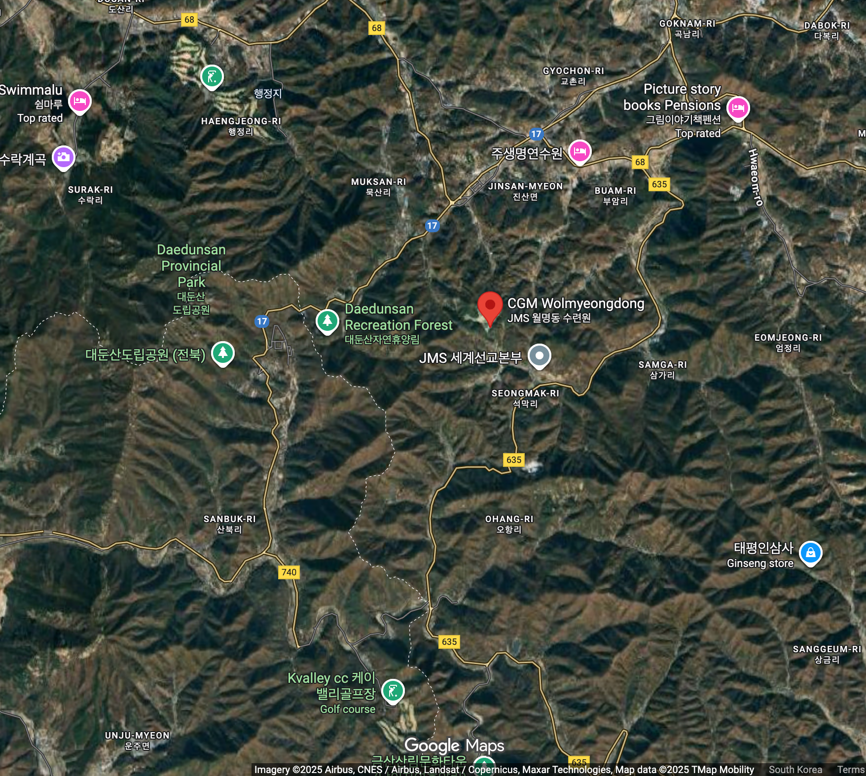
Google map
This single image virtually ends the myeongdang debate:
the most basic condition — a mountain to the north — is missing.
Therefore, JMS sermons that reference concepts like Blue Dragon on the left, White Tiger on the right, or Ziweiyuanguo don’t even merit serious discussion.
If we stretch the definition and consider the northwest direction as north, what kind of site is Wolmyeongdong then?
Geomancy divides auspicious sites into two categories.
One is for the living (yangtaek): flat land surrounded by mountains to the north and rivers to the south — ideal for homes.
The other is for the dead (eumtaek): gently sloping hills with similar surroundings — ideal for graves.
We talked about it at the observatory earlier, but the truth is, there wasn’t just one or two people who wanted to develop this place before me. I was a bit late. I almost let someone else develop it first.
One person intended to develop it as a public cemetery, and another was enlightened with the idea that all those who had left their hometown would come here, build a small house, and visit occasionally to get some fresh air now that I had become a pastor. Because I moved to Seoul so late, I thought I shouldn’t return until at least ten years had passed. How could I just come back? I needed to achieve something first… Otherwise, how could I tell the people back home that I was doing something in Seoul? Wouldn’t it be embarrassing to say I was ministering to just a few hundred people?
— Sunday Sermon, April 2, 1995
The distinction between the two types of myeongdang lies in whether the land is flat or hilly.
So which is Wolmyeongdong? Flatland or hillside?
It is hilly terrain — which, strictly speaking, would make it more suitable for a cemetery.
Indeed, one story says that a wealthy man once sought to turn the Wolmyeongdong area into a public cemetery.
Within JMS, this story is told as one of divine intervention: that God helped Jung secure the land.
But from another perspective, it’s also a record that someone once saw the site as suitable for a burial ground.
“A High Place”
Another frequent claim is that Wolmyeongdong is a high-altitude area.
Sermons state that Daejeon — a nearby city — is higher than other major cities, Geumsan even higher, and Wolmyeongdong the highest of all, at around 400 m above sea level.
There are many things you need to know about this place. This area is generally quite high. 1) The place with the highest average elevation in our country is Chungcheong-do. Before, everyone used to say they’d move up to Seoul, but that’s like saying the sun rises. It only seems like the sun rises because the Earth rotates. 2) Our country has the same latitude as Israel. And the highest place in Chungcheong-do is Geumsan. Even the rice paddies in Geumsan are over 200 high-altitude meters. That’s why they built the satellite communication center there. There are several myeon (townships) in Geumsan, and the highest myeon is Jinsan-myeon. 3) Jinsan-myeon is an area that has risen up where the Noryeong and Charyeong mountain ranges converge. That’s why there are several mountains like Indae-san, Daedun-san, and Handum-san. We might not perceive it as high, but it is, in fact, a high place. 4) Out of the 28 villages in Jinsan-myeon, the highest village is Seokmak-ri, and the highest ban (sub-village) within that is Wolmyeongdong. Even the sports field in Wolmyeongdong looks level, but there is an elevation difference of over 30cm between one end and the other. That’s why the water drains well. So there is a huge difference in elevation between Seokmak-ri and here, and Buam-ri and here. 5) There is also Ohang-ri, but you have to go down quite a bit to get there, so it’s lower than here. Anjiraengi is also there, but you go down even further. The place where the birthplace was torn down is address 151, and that is the highest point.
And the river close to here is the Geum River. The Geum River water flows out to Gunsan, and if you go up from Gunsan, you reach Buyeo. In Buyeo, it is called Baekma River. There is no separate Baekma River. It came up from there to Daejeon, and came to Anyeong-ri, the line that went to Muksal-ri stopped there, and one stream came up to Seokmak-ri and went up to Dalbakkol (Wolmyeong Valley). 6) Therefore, this is the highest headwater of the Geum River. Many people gather to see the source of a river.
— Morning Service, August 5, 1997, “The Ideal World of Eden” (Genesis 2:4–17)
Wolmyeongdong is a very high-altitude region. It is the highest area among all Korean cities, including Seoul, Daejeon, Daegu, Busan, and Gwangju. The elevation of Korean cities is only about 50m to 100m above sea level, and among them, Daejeon is considered high at 70m to 100m above sea level. Even in Gangwon-do, the ‘mountains’ are high, but Donghae, Samcheok, and Gangneung are only 10m, 20m, or at most 30m to 40m above sea level.
The floor of the flat land in Geumsan is 250m above sea level. Because it is flat yet so high, they built the ‘Cosmic Satellite Communication Antenna’ there. The ‘Cosmic Satellite Communication Antenna’ needs to be as large as a huge stadium, but A) they have to set up five of those big antennas. Therefore, B) no matter how high a mountaintop is, they cannot install antennas there. That’s why they built the ‘Cosmic Satellite Communication Antenna’ in Geumsan, the highest flatland. C) Since it is flat yet 250m above sea level, it’s equivalent to installing the antenna on a mountaintop.
— “Heaven’s Throne and Earth’s Throne”, October 19, 2014
“◇ Wolmyeongdong is a high place.
I have mentioned this in many sermons.
Looking at the average elevation of major cities in Korea:
Daejeon (58 m) is higher than Seoul (38 m) or Busan (4 m), and even higher than Gangneung (5 m).
Geumsan County is about 4.3 times higher than Daejeon,
and higher than Seoul’s Namsan Mountain (243 m).Average elevation:
Daejeon (58 m) – Daegu (44 m) – Seoul (38 m) – Gwangju (16 m)
Incheon (7 m) – Busan (4 m) – Ulsan (4 m) – Gangneung (5 m)
Geumsan County (250 m) – Seoul Namsan (243 m)
The highest city in Korea: Taebaek (902 m)Among the districts of Geumsan, Jinsan-myeon is the highest,
and within Jinsan-myeon, Seokmak-ri is the highest village.
Within Seokmak-ri, Wolmyeongdong is the highest area — around 400 m above sea level.”— Sunday Sermon, August 20, 2023
Sermon records show that this theme reappears repeatedly over the years.
But are Daejeon and Geumsan truly among the highest cities in Korea?
Using a generative language model, I investigated the average elevations of Korean cities.
Comparison of Korean Cities by Average Elevation
| Region | Average Elevation (m) | Note |
|---|---|---|
| Seoul | ~38 m | Central lowlands of the capital area |
| Busan | ~4 m | Coastal plains |
| Incheon | ~7 m | Mostly coastal lowlands |
| Gwangju | ~16 m | Low city center with surrounding hills |
| Daegu | ~44 m | Slightly elevated basin terrain |
| Daejeon | ~58 m | Typical inland elevation |
| Yongin | ~125 m | Highland area within the Seoul metro region |
| Chuncheon | ~76 m | Inland basin |
| Wonju | ~130 m | Gentle hills of Gangwon interior |
| Jecheon | ~380 m | Mountain basin city |
| Taebaek | ~902 m | Highest city in Korea |
| Geumsan County | ~250 m | Based on survey data |
| Jinsan-myeon | 300–450 m | Based on actual measurements |
Source: ChatGPT 5, cross-verified from multiple public datasets
The results show that there are many cities at higher average elevations than Daejeon or Geumsan — such as Yongin, Chuncheon, and Wonju.
Analysis of Sermon Text
Next, let’s examine the sermon statements line by line.
(1) “The highest region in Korea on average is Chungcheong Province.”
According to Wikipedia, South Chungcheong Province is mostly flat, with no area exceeding 1000 m, and its average elevation is below 100 m — the lowest among all Korean provinces.
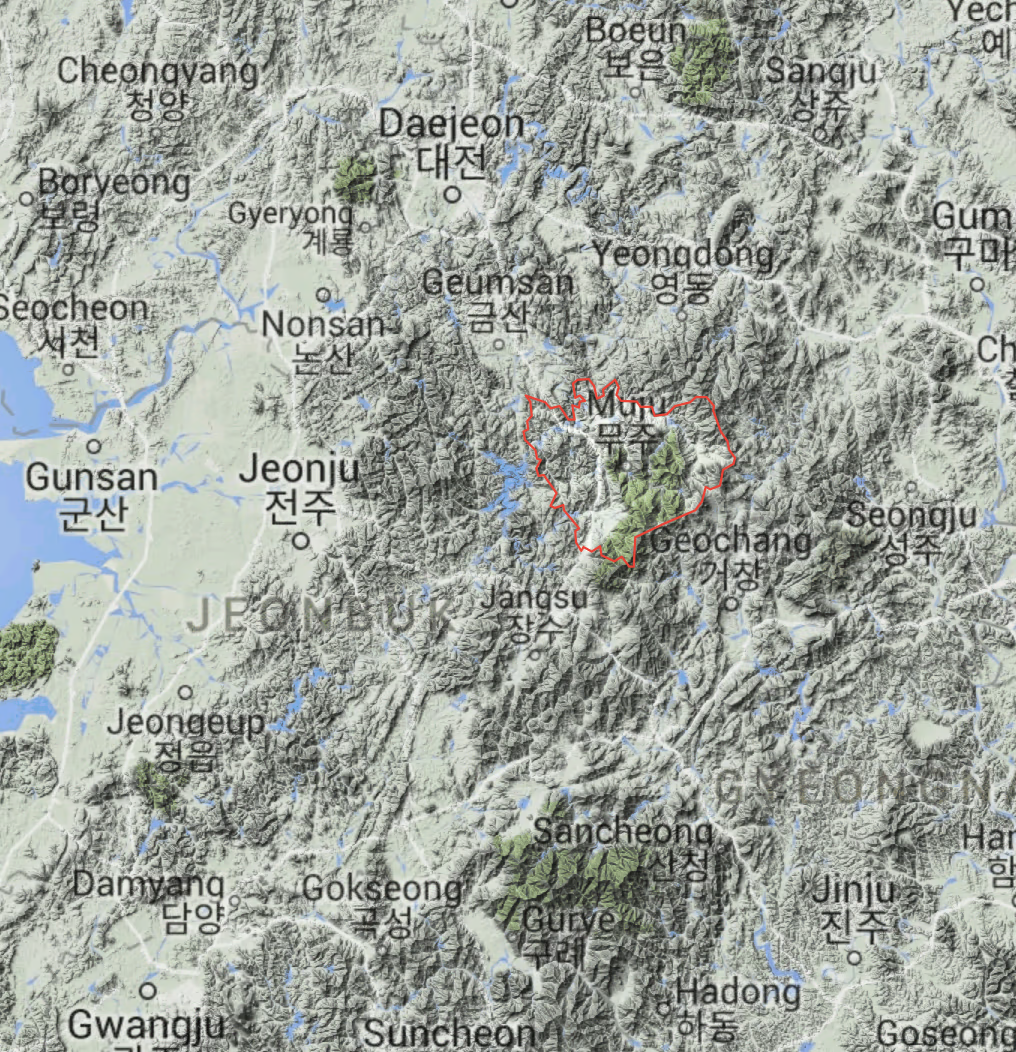
A comparison with nearby Muju County in North Jeolla Province shows that Muju is significantly higher, with mountains between 700–1000 m and narrow plains around 300–600 m.
Google Earth, ©2021 SK telecom
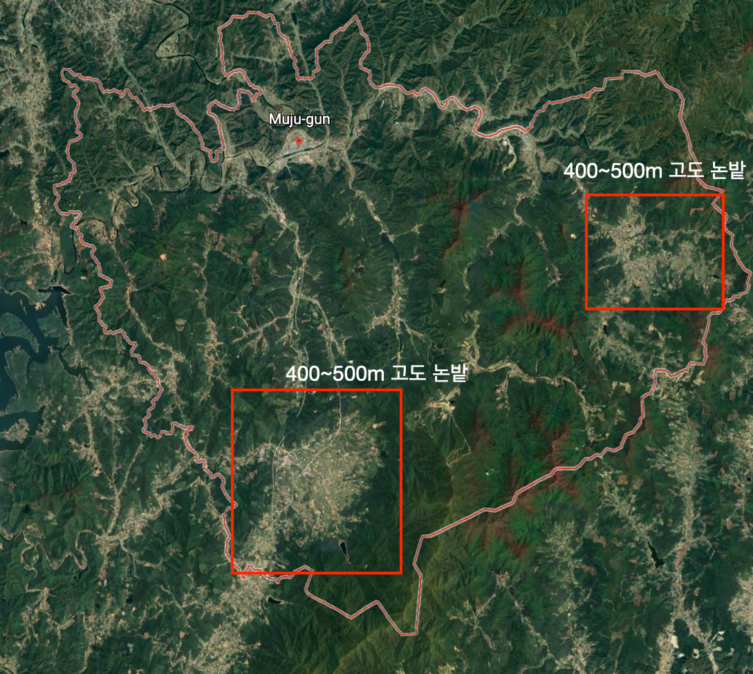
Google Earth, ©2021 Maxar Technologies, ©2021 CNES Airbus
Satellite images confirm that the densely populated areas to the south and northeast lie at elevations between 400–500 m.
(2) “Korea is at the same latitude as Israel.”
Wolmyeongdong’s latitude of 36° N corresponds to northern Syria — much farther north than Israel.
(3) “Jinsan-myeon is where the Noryeong and Charyeong mountain ranges meet.”
In fact, the Charyeong Range runs through Chungcheong and Gyeonggi, but it does not intersect the Noryeong Range.
(4) “Among Jinsan’s 28 villages, Seokmak-ri is the highest, and within it, Wolmyeongdong is the highest.”
Google Earth shows that Wolmyeongdong’s sports field sits at an elevation of about 350 m — the same as the parking lot of Daedunsan Recreation Forest.
(5) “Ohang-ri is much lower.”
Ohang-ri lies behind Indae Mountain overlooking Wolmyeongdong.
Satellite data show that its elevation is roughly similar or slightly higher.
(6) “This is the uppermost source of the Geum River.”
However, the Geum River’s true headwaters are the Tteunbong Spring on Mt. Sinmu (897 m) in Jangsu County, North Jeolla Province.
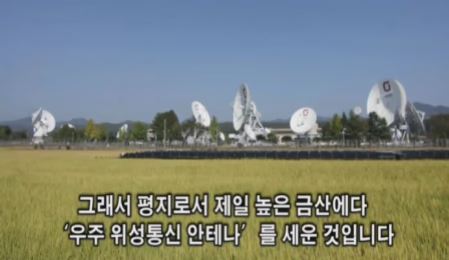
Sermon still, Oct 19, 2014
(A) “Five large antennas were built there.”
In the sermon image, five large antennas appear in the front, but upon closer inspection, several more are partially hidden or distant.
Satellite photos via Google Earth reveal over 30 antennas, not just five — clearly a factual mistake in the sermon.
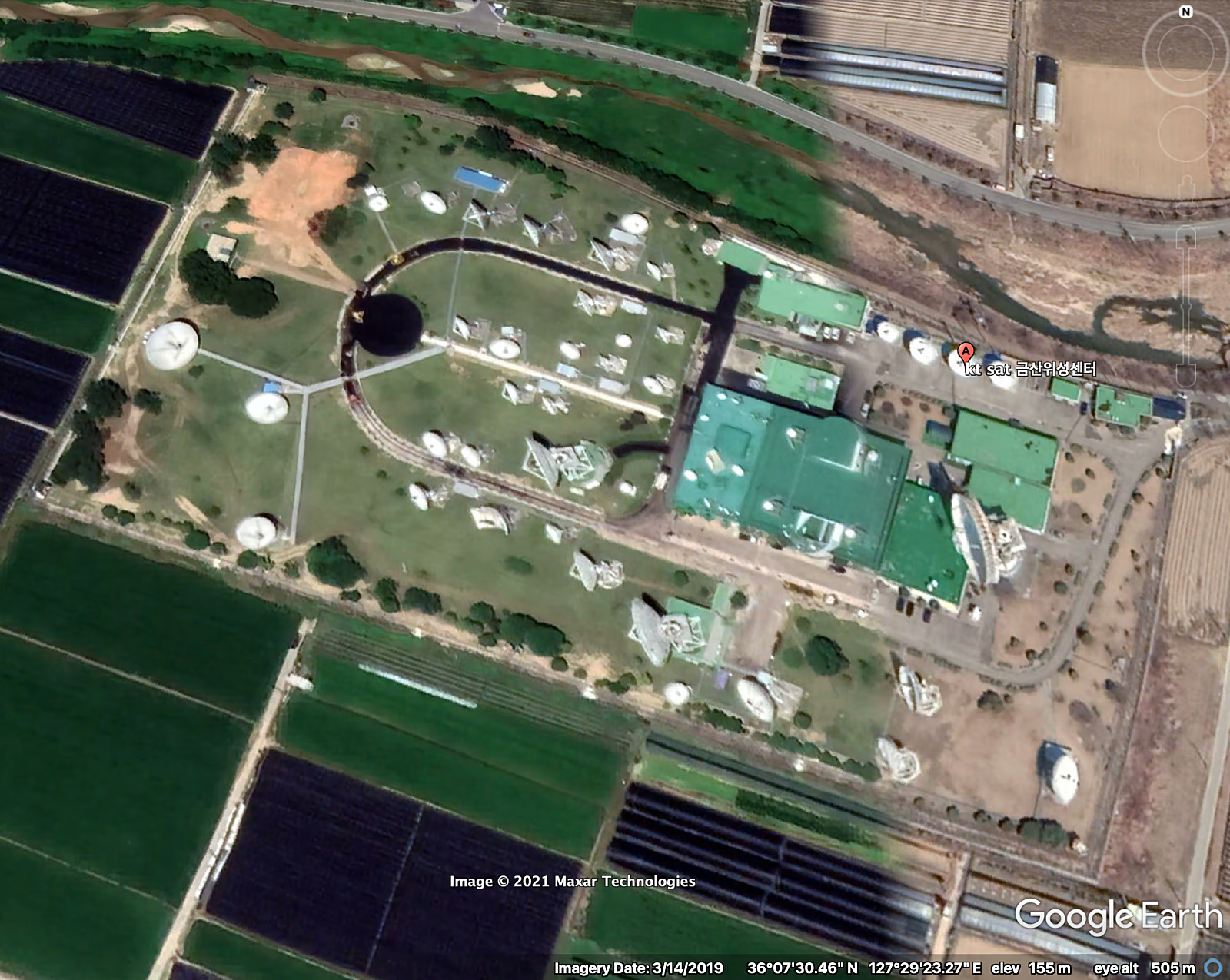
Google Earth
(C) “Even though it’s flat land, it’s 250 m above sea level — like building antennas on a mountaintop.”
Google Earth data show the elevation of the Geumsan Satellite Center is around 150 m, lower than the 210 m elevation of the Boeun Satellite Center.
(B) “Antennas cannot be built on mountaintops.”
“The reason the 61,929㎡ Geumsan Satellite Center was built here is that it offers ideal weather for stable satellite communication.
The area, surrounded by 400–900 m mountains, experiences many hot and clear days.
Its location — where the Pacific and Indian Ocean coverage overlaps — also makes it strategic for both land and maritime communication.”— “Why KT Built Satellite Antennas Amid Ginseng Fields,” iNews24, June 7, 2018
Thus, the Geumsan Satellite Center was not located there because of high altitude,
but because the weather is relatively dry and stable — and the site is geographically optimal for satellite coverage between the Pacific and Indian Oceans.
Note
The translated portions of this text were generated using machine translation and may contain unnatural expressions or errors.